Planning with Water, Part 3
-
-
ListenPause
I’m Peter Neill, Director of the World Ocean Observatory. In the past few editions of World Ocean Radio, I have been addressing the recognition of the global water crisis, its relationship to the effects of climate change, and its implications for the future provision of this most valuable commodity and for worldwide health and security. I have suggested water as an alternative to coal, oil, and gas as a standard around which we calculate value and organize our communities, economies, and international relationships. It may seem a drastic idea, but if you take some time to think it through, you may discover a compelling logic, a recalculation of value, a strategy for action toward a realizable future using existing technology and re-allocated financial assets. How would it work? Let me give you an example of a planning initiative that speaks to the why and how. The Nile River Basin comprises 3 million square kilometers along a 6,695 kilometer course starting at the headwater in Rwanda and Burundi, support millions in ten riparian nations along the watershed, and descending to Egypt and the Mediterranean Sea. The river’s erratic flow, and the associated activities supported by that flow, has been severely impacted by climate change factors – temperature rise, persistent droughts, extreme weather, flooding, and the inevitable social-economic consequence in terms of energy and food production, health and sanitation, employment, poverty, and regional security. The UN Environment Programme (UNEP), in cooperation with the Nile Basin Initiative (www.nilebasin.org), with support by the Swedish International Development Agency, retained the Danish Hydraulic Institute (www.DHIGroup.com), to gather all available data regarding all activities and needs throughout the watershed, to generate from that data a complex hydraulic model through which to model climate change projected effects, growing demand, and multiple requirements for water resources throughout the entire basin over time. The DHI, a non-profit consulting firm chartered by the Danish Government, has developed proprietary software capacity that can assimilate massive amounts of data and make it adaptable for testing impacts of projected future conditions and scenarios. It is an astonishing planning tool. The Nile model includes rainfall, runoff, lakes, reservoirs, dams, wetlands, and irrigation water demands. The projections applied cover two thirty-year periods – from 2020 to 2049 and from 2079 to 2099. Comparing the changing capacity with population growth, rural and urban shifts, agricultural and manufacturing needs revealed not just what amount of water might be available, but also how what is available can be efficiently and effectively managed. From this information, very specifically located in a place, a region, a settlement, or a nation, decision-makers were provided with informed conditions on which they could evaluate and place water dependent uses, target limited financial resources, and understand the management practices and professions for which to train personnel to operate the system in the future. Please take a moment to think about the implications of this, not only for the Nile River, but also for all the other multi-state and trans-national watersheds around the world that could benefit from a similar understanding of the hydraulic reality on which their future viability will depend. For such a system to work requires local knowledge, communication, cooperation, implementation, evaluation, and further planning and action – all bringing together managers from nations sometimes antagonistic over other issues, but understanding that without such an agreement and collaborative action, the absence of adequate water supply at any point along the line will lead to deprivation and unrest. Apply this methodology to any waterway you know and you immediately see how decisions made up-stream or down, indifferent to conditions down-stream or up, are the instigators of competition and conflict that most often does not serve anyone well. The Nile Initiative is just one amazing example of planning with water. If nations can find consensus and compromise around water as an egalitarian human right, what else might they find possible through this first success? What other agreement might be found through the understanding and experience derived from one system that unites us all? We will discuss these issues, and more, in future editions of World Ocean Radio.
In this episode of World Ocean Radio host Peter Neill continues a discussion about the most important issue facing the world today: the global water crisis. This week he highlights the Nile River Basin and a multi-institutional planning initiative on that massive and complex waterway which could be adapted as a tool for managing water assets on other interstate and trans-national waterways around the world. This episode is part of an ongoing series that looks toward building a new value premise and societal change around water as the most valuable commodity on earth, essential to our future survival.
About World Ocean Radio:
Peter Neill, Director of the World Ocean Observatory and host of World Ocean Radio, provides coverage of a broad spectrum of ocean issues from science and education to advocacy and exemplary projects. World Ocean Radio, a project of the World Ocean Observatory, is a weekly series of five-minute audio essays available for syndicated use at no cost by college and community radio stations worldwide. A selection of episodes is now available in Portuguese, Spanish, French, and Swahili. In 2015 we will add Mandarin to our roster of global languages, enabling us to reach 75% of the world's population. For more information, visit WorldOceanObservatory.org/world-ocean-radio-global.
Resources from this episode:
< UN Environment Programme (UNEP)
< Nile Basin Initiative
< Swedith International Development Agency (SIDA)
< Danish Hydraulic Institute
< Adaptation to Climate-change Induced Water Stress in the Nile Basin: A Vulnerability Assessment Report (PDF)
"Planning with Water" Series
< Part I
< Part II
< Part IV
Image:
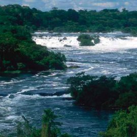
Bujagali Falls, the Nile, Uganda (used courtesy of UNEP)
- Login to post comments


